General
Mustang District, a part of the Dhaulagiri Zone, which is also known as "Land beyond Himalayas" is located in the Kali Gandaki valley of the Himalayan region of Western Nepal. Mustang (from the Tibetan Muntan meaning "fertile plain") the traditional region is largely dry and arid. The world’s deepest gorge that goes down three miles vertical between Dhaulagiri and Annapurna mountains runs through this district. It also houses several of the most inspiring historical sites in the country, some of which date back to four thousand BC.
History

Mustang was once an independent kingdom, although closely tied by language and culture to Tibet. The word Mustang is derived from its original name –Lo Mustang. During 1400 AD and 1600 AD, Lo Mustang dominated the Kali Gandaki trade between India and Tibet, as it was the borderland of Nilgiri west Tibet. In the 11th century, a declining Lo was forced to pay levies on its river trade to the kingdom of Jumla further west. After 1975, when the expanding of Gorkha Army of King Prithivi Narayan Shah defeated Jumla, Lo transferred its levies to Gorkha. Although akin to Tibetan culture as well as language, Lo supported Nepal in the war with Tibet, thus affirming its ancient feudal system of Rajas. Then His Majesty the King of Nepal to the Raja of Lo bestowed the title ‘Raja of Mustang’ till 2006 AD. The people of Lo are predominantly Buddhist and speak Tibetan and Nepali. During the 1960’s, Lo became the operation base camp for the Khampa guerrillas from east Tibet fighting the Chinese occupation of Tibet.
Habitation and the Places of Interest

Mustang district is divided into three main sectors. Baragaon is located north of Jomsom, panchgoan is situated in between Jomsom and Marpha, and the Thak states lies south of Marpha. Baragoan was also known as ‘Lower Lo’ and for a long time was ruled by the Mustang Rajas. Baragoan also houses Muktinath, a shrine revered by both local inhabitants and Hindus. The remote shrine of Muktinath is a most sacred pilgrimage site for Hindus. This temple has attracted both Buddhist and Hind pilgrims for hundreds of years. Hindu regard the idols of this shrine as God Visnu where as the Buddhist regard it as Lokeshwor. Panchgoan is home to the Thakalis, who are known to have converted to Buddhism under Tibetan influence. Tilicho Lake falls in the bordering Manang district at an altitude of 16,140 ft. It is the Highest Lake in the world and is at a day’s trek from Kaisang camp.
The District Headquarter, Jomsom

Since the early 1970s, Jomsom has been the district headquarter of Mustang. It also houses the HAMWS. The name of Jomsom is a Nepali deformation of the Tibetan ‘Dzong Sampa’ meaning ‘New Fort’. The inhabitants of Jomsom are mostly traders of the Thakali tribe. They are of Tibetan origin. The people living near Thak Khola were later called Thakali.
The people

The people from southern Mustang regard themselves as the real Thakalis. The Thakali tribe is divided into two sects, the Tamang Thakalis who are Gauchnan (elephant, red) Tulachans (dragon, blue/red), Juharchan (jewel) and Pannachan (emerald). The Thakali have customs distinctly different from other parts of Nepal. The Thakalis fall among one of the richest ethnic groups of Nepal. These people attribute their prosperity to the monopoly of the trade route of Kali Gandaki for several centuries. For the last quarter century Thak Khola region has also contributed significantly in the development of tourism in Nepal.
Annapurna Conservation Area Project (ACAP)

Launched in 1986, the Annapurna Conservation Area Project (ACAP) is the largest undertaking of National Trust for Nature Conservation and also the first Conservation Area and largest protected area in Nepal. It covers an area of 7,629 sqkm. and is the home of different cultural and linguistic groups. ACAP is rich in biodiversity and is a treasure house for 1,226 species of flowering plants, 102 mammals, 474 birds, 39 reptiles and 22 amphibians.
The natural and cultural features have made the Annapurna region a unique place in the world. The biological diversity of the Annapurna region is equally rivaled by cultural diversity.
The multifaceted problems of ACA have been addressed through an integrated, community based conservation and development approach, an experimental model which has been in the vanguard of promoting the concepts of “Conservation Area” through an “Integrated Conservation and Development Programme” approach in the country and abroad. ACAP was first tested as a pilot Program in the Ghandruk Village in 1986. After being notified in the Gazette as a “Conservation Area” in 1992, ACAP’s program covered the entire area.
ACAP has been divided into 7 unit conservation offices - Jomsom, Manang and Lo-Manthang in the trans-Himalayan region and Bhujung, Sikles, Ghandruk, and Lwang on the southern flank of the Annapurna range. The focus of Jomsom, Manang and Ghandruk, which are among the most popular trekking destinations, is on integrated tourism management and other development activities that benefit the local communities and the environment.
How to Get There

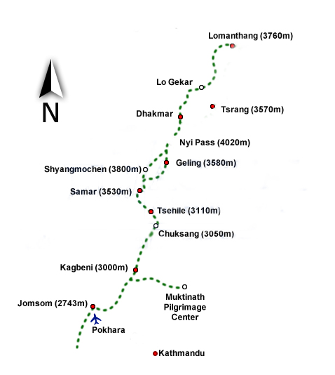
One can reach Mustang district by road, air or trekking. There is a daily flight and bus services from Pokhara to Jomsom. Helicopters can also be chartered from commercial airlines. There is an abundance of lodges along the trekking route. The police check-posts along the trekking route ensure the security of the tourists. Telephone facilities are available in most of the villages along the route. The district post office is situated in Jomsom and banking facilities are also available there.
The land
Location: 28.20’ to 29.05’ N - 83.30’ to 84.15’ E
Total area : 3573 sq.km
Altitude : 2,000 meters to above 8,000 meters
Wet and Dry Seasons:
July to September (Rainfall 184 mm)
March to June/October (Rainfall 5 mm)
Max and Minimum Temperature:
26 Degree Celsius (June-July)
Minus-12 Degree Celsius(Jomsom) (December- January)
Snowfall : November to February (15 to 30 cm)
Rivers: Kali Gandaki River, Lampodyang Khola, Lete Khola, Thini Khola, Marpha Khola, Ghami Khola, Thak Khola, Chokhopani Khola.
Major peaks: Dhaulagiri (8,167m), Nilgiri (7,060m), Tilicho (7,132m), Yak-Kawa (6,482m), Tukuche (6,013m),Thorang (6144m).
Ethnic Group: Thakali, Loba and Baragaunle
Economic activities : Trade, Tourism, Wage Labor, Porter, Agriculture and Animal Husbandry.
